An Autumn Sunday afternoon walk around Rawhead

Rawhead_Julia.jpg

By Julia Bennett

Driving eastwards past the 150 year old mining engine house chimney - a lieu de mémoire for the dark dirty-secret past of this green and pleasant corner of England. This is the old Salt Road. Salt was carried from the Cheshire 'witches', the towns of Middlewich, Nantwich and Northwich, to the port at Chester, and later Liverpool, to trade with Africa and Asia. Up the steep Coppermine Lane to reach the top of the ridge. Squeezing in amongst a crowd of Sunday cars on the side of the road.

The path heads off. A stony farm road leading first west and then south towards Whitchurch. This is the Sandstone Trail tracing the sandstone ridge along the western side of Cheshire for 55 kilometres.

The potholed track soon dissolves into a footpath. Skirting the edge of the steep wooded hillside:

silver birch leaves burnished gold;

blood red rowan berries;

prickly sweet chestnut tempting hungry squirrels.

Trees frame distant views:

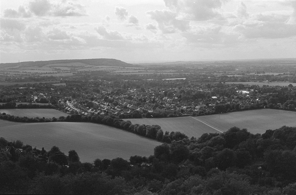
north across the Mersey, the solid square-built sandstone tower of Liverpool’s Anglican cathedral; closer, a cluster of slim flame-topped stacks pinpoint the oil refineries at Ellesmere Port. Closer still the Roman City of Chester hunkers down on the banks of the river Dee all but hidden in the folds of gentle rolling green pasture, that most English of English landscapes extending to the very edges of the country before drowning in the waters of the Dee.

… black rooks somersaulting against the blue-grey sky …

Across the fields to the east, beyond the giant white saucers of Jodrell Bank, the hazy beginnings of the Pennines.

… pinky-brown chaffinches flash white stripes as they flit from bush to bush …

The path narrowly clings to the edge of the soft, red sandstone cliffs. Cliffs formed during the Triassic period 250 million years ago, says the information board, once upon a time, a long, long time ago.

Not so very long ago, in the 1220s, Beeston Castle was built on a rocky outcrop, here in bas relief against the sky, a five kilometre walk north on the trail. Once upon another time it was the site of one of the Iron Age hillforts strung out along the ridge like a ‘join the dots’ guide to life here 3,000 years ago. . . . the trail following in ancient footsteps.

Steps lead down the side of the hill to a wooden platform. This is Dropping-stone well. Local people climbed up here to fetch drinking water as recently as the Second World War. In the not so distant past servants took sand from the caves which pockmark the soft sandstone to use on stable floors and as a scouring aid in the kitchens of the ‘big houses’. This was a busy, productive place, and not only on Sunday afternoons.

Rawhead itself, the trig point and the highest part of the Sandstone Trail stands at 227 metres. Rocks jutting above the trees, there are clear views from here. Over the border into Wales, Wrecsam’s industrial estate stands out against a background of the Clwydian Hills. Shropshire to the south and on a (very) clear day a faint outline of the Wrekin about 30 miles away.

The path turns southwards, continuing to snake along the very edge of the steep cliffs. Careful footsteps are needed to avoid sliding over the edge into the canopy of silver birch and scots pine that cloak the sides of the cliffs. Black holes mark caves in the rock faces.

A turn to the east. Rhododendrons flood a steep valley. A dull green for much of the year, in spring this ‘alien species’ large purple flowers are a prelude to the native purple heathers and plump ripening bilberries yet to come.

A small wood of scots pine, a cluster of farm buildings, the path runs next to a field separated by an electric fence. Noises off:

in the spring a cuckoo;

summer occasionally brings the insistent tapping of woodpeckers;

autumn, the rustling of pheasants in the maize stalks;

crows and farm dogs scrap and shout for attention all year round.

Down towards the kissing gate and the farm track. The Sandstone Trail turns towards the main road and southwards to Bickerton Hill. The sign to the Bickerton Poacher points left. This path follows behind the line of the fields and houses which border the main road. Overhung with stray fruit trees, damsons and crab apples tempt those walking beneath.

Crossing the muddy stream at the lowest point of the path, then uphill again past the memory of the industrial past: the brick chimney above Gallantry Bank.

Buzzards haunt the tall scots pines edging an open field, swooping ghostly shadows a prelude to their loud territorial claims. Shooting parties gather in this space. Gallantry is an elision of ‘gallows tree’. Hiding history in plain sight.

Over the stile and a steep climb up Coppermine Lane brings us back to the present.

Julia Bennett is a sociologist with an interest in place and belonging. She has lived in this part of Cheshire for 16 years.

Catholic Ghosts on Vauxhall Road

Vauxhall Road 1.jpg

By David Lewis:

Note:

Liverpool has a small old Jewish community but, as Islam and Hinduism are traditionally not strong faiths in the city, even now there are few mosques or temples.   The religious landscape, fading or vigorous, is overwhelmingly Christian.  Once the division between Catholic and Protestant was deep and strong.  Protestant Orange Lodge marches and Catholic celebrations of St Patrick’s Day could lead to violence.  Schools were segregated on sectarian lines and even the football teams were divided between Catholic Everton and Protestant Liverpool.  These faultlines have largely disappeared. 

The new city can pall; too much glass, too much steel, too many towers.  I turned inland to hunt ghost pubs, the alcoholic ruins along Vauxhall Road, where derelict Victorian public houses stand like broken teeth in a new urban landscape.  The Atholl Vaults, boarded and violated, plaster crumbling; the Castle, alive but closed; the Glasshouse on the corner of Eldon St; and wildernesses of bramble and buddleia behind faded advertising hoardings, the sites of mourned pubs like the Great Mersey, their ghosts silent.

Vauxhall Road 3.jpg

On Eldon Street I turned to the Catholic church of Our Lady of Reconciliation.  Scaffolding and tarpaulins dripped with rain and melting frost, as if the huge church had just risen from the bottom of the sea. This was a strong Irish Catholic district, fiercely political.  The area returned a Nationalist MP to the British parliament for over forty years, and a store of pre-IRA weapons was found in the cellars of a local pub in the late 1800s.   But I found that this pub too had been demolished, leaving only a brick scar.  I thought about taking one of the old bricks, to have a small piece of Liverpool Irish Nationalist history.  But why?  Perhaps one day the sounds in inanimate objects will be heard; the anxious voices, the thuds and curses as the boxes of rifles were manhandled downstairs; but not in my lifetime. 

From lost pubs, I began to see Catholic ghosts in road names and old churches.  This was now a meander across a landscape of invisible parishes, destroyed shrines torn apart in the mechanised Reformation of the 1960s when Liverpool savagely regenerated many of the older districts.  On Titchfield Street I found cobbles beneath the tarmac, stone Victorian ghosts, which took me to Trinity Catholic Primary School.  A trinity of Anglican churches - St Martin’s in the Fields, St Alban’s and St Titus’s - were lost many years ago.  The towers and walls of the Catholic St Sylvester’s survive, but they are embattled, razor-wired against vandals and arsonists, gradually being smothered by buddleia.  St Brigid’s has suffered even more.  Demolished for the Kingsway Tunnel, a slash of Brutalist concrete, it survives only as a place name behind St Sylvester’s, a clustering of Catholic names gathered as if for safe keeping. 

There are deep echoes of the Reformation on these old streets.  St Sylvester’s stands near Latimer Street, named after the bishop who was martyred for his Protestant faith.  Catholic churches, Protestant streets.  Churches stand empty, street names have lost their meanings.  Nobody in Liverpool takes these divisions seriously any more, only rain-tramps like me, trudging these darkening streets; only gutter-historians, church-watchers, people who care for the memories of the city.  And we do not believe, we just remember. 

Vauxhall Road 2.jpg

The people are still here, of course.  Old terraced houses have gone and bungalows and semi-detached houses with gardens and driveways line the streets.  Pubs and churches are the last to go, closed, abandoned to the weather, and then demolished, their love and faith dispersed, forgotten.  But the people remain, living modern lives in a landscape of fading Victorian ruins, architectural, cultural, theological. 

My last ghost was a church that I had watched disappear.  St Gerard Majella’s was a strange brick and concrete church near Scotland Road, and I watched it’s demolition over a month or six weeks.  The brick tides of the city have closed over this sunken church, and the name survives only in a street and a new courtroom.  I contemplated a further walk to Cranmer Street, another martyred bishop, another faded street bookended with ghost churches; but the rain was heavier and the day was darkening.  I turned towards the river, and walked slowly down to the warm shiny truths of the new city. 

David Lewis has written five books of history/landscape/psychogeography about his native Liverpool and Merseyside.  He posts urban/rural images on Instagram - davidlewis4168 and mutters about the world on Twitter - @dlewiswriter

Countdown

Ian Smith Countdown.jpg

By Ian C Smith:

In nocturnal limbo, untethered from sleep since 2.30, body aching, checklist of not-to-be-left-behinds reducing like ended experiences sintering away, months morphing into years, or waves washing below the light aircraft he boards in hours and minutes counting down, he can’t stop check-listing a spun out life.

Averse to a homecoming of smelly rot, tiny insects swarming in decomposed matter in the silence below his sink, he deposits kitchen scraps in the compost, balancing this by removing some for scabbed garden spots, trowelling through a fecund reek writhing with worms before leaving for his beloved place, a shimmer of memories.

Repositioning items in two battered bags, he mulls over squeezing in a book he is nine-tenths through, a literary heavyweight as big as a best seller with a title of reducing numbers by a favourite writer, a rich rendition of possible paths taken in an artistic life.

Immersed in its saga, he is unable to leave the book behind, checks another item off, medication, considers arithmetical probabilities, how happiness can remain a hairsbreadth away, loved photos, angled light blessing an island, shrouded reminders of a life, prowling his mind’s distant alleys, treading softly through the dark stables of the past. 

About the author: Ian C Smith’s work has appeared in, Amsterdam Quarterly, Antipodes, Australian Poetry Journal,  Critical Survey,  Live Encounters, The Stony Thursday Book, & Two-Thirds North.  His seventh book is wonder sadness madness joy, Ginninderra (Port Adelaide).  He writes in the Gippsland Lakes area of Victoria, and on Flinders Island, Tasmania.

Postcard from... Tarragona

Tarragona.jpg

By Tim Woods:

A string of global top ten hits; a world-famous fashion icon; the star of era-defining TV shows. But when you hear ‘Minogue’, do you immediately think ‘Dannii’?

Tarragona suffers from a similarly overbearing sibling. It has everything a visitor could want from a Spanish excursion – coast, culture, cuisine and cerveses – yet for many, Catalonia means one thing: that overcrowded, football-famous metropolis up the coast. Even names such as Sitges and Salou will often chime more readily. These nearby resorts offer little more than sun, sangria and “Full English, only €15!!!”, yet still attract more tourists. Some hotels even offer trips to Tarragona as an afternoon excursion: “Only four hours there and back!!!”. Being little more than a time-killing detour from these culturally devoid upstarts must be hard for a former Roman capital to bear.

Yet could the times be changing? Barcelona’s authorities are actively turning tourists away, and there are only so many boiled-lobster beach-lovers that can be squeezed onto a beach. There is a void to be filled, a market to be served, and Tarragona is more than equipped to step up.

Late afternoon, I lose myself in the constricted alleys of its honeycomb old town, the docile ochre of the buildings disrupted by the Catalan flags that flap from every other balcony. I am hardly alone; a steady stream of tourists meander with me, and we are all eventually drawn to the steep steps of the cathedral, where perching space is at a premium. But drift along any of the streets that radiate from this central point and you have space, time, quiet; a stillness rarely found in Barca.

I head to the rambla, where I can actually ramble, rather than being jostled along with a crowd’s haste. Fish and tapas restaurants flank either side, but there are spaces to be had at the tables. The tiny bars selling home-flavoured vermouth are hidden just a couple of streets away. Later, I head to the Balcó del Mediterrani. It’s a hazy, lazy evening, perfect for outside, yet there is still ample room at the city’s prime lookout, from where you can soak up the ancient Amfiteatre to the north, or the fishing boats spinning around at sea.

Humbler Roman sites crop up unexpectedly. Next morning, in search of watermelon for a hungry toddler, we stumble upon the Teatre Romà de Tarragona. This spectacular site pops up unexpectedly; there are no signs, no tour parties, no fuss or fanfare. It’s just there, should you want to see it.

Or not. Up to you.           

Tim is an editor on Elsewhere: A Journal of Place and the author of Love In The Time of Britpop. You’ll find him on twitter here.                 

Beacon Bound, Part IV: Momentum

Stripes.jpg

In memory of his grandfather, Nicholas Herrmann walks the length of The Ridgeway: an ancient road stretching for eighty-seven miles across chalk downland, from Overton Hill to Ivinghoe Beacon. We will be following Nicholas’ journey here on the Elsewhere blog over the next couple of months.

As I round the corner a field comes to life, spiralling into the sky. I count twenty before they tornado away, another nine still hunched in the sun. The air is a solid wall of wings. This could be normal for all I know, but it feels like an omen: the universe flexing, a flurry of autumn heralding the end. I lift my camera too late, and through glass watch as the storm of kites blows silently over the hill.

But this is later. The day starts where we left off: by the walls of the neighbourly Church of the Holy Trinity, where we’re offered tea and biscuits before we’ve even begun. A kestrel splashes above the Ridgeway, treading water in the sky. Soon, the path is swallowed by a golf course, so we hunt for waymarks, following a trail of painted acorns. My skin prickles as I pass over dead patches on the manicured lawn – grass singed in the recent heatwave. Today, the conditions for walking are good: cool and overcast. We’ve finally made it to the other side of summer.

Berries.jpg

Like deer, we slip across a road and into the trees, passing through alternating woods and fields of flint. The forested strips are tangled and dim, but autumn’s psychedelia is already spreading. The flash of an arum lily blazes through the late-summer green. Branches droop with dark clumps of elderberries and the shadowy orbs of sloes. Ripening rose hips blush between the leaves. Hawthorns radiate red. At intervals, we pause to gorge ourselves on blackberries, quietly marvelling at their galaxies of flavour: rich, soft, syrupy, like wine. We have entered the treasure season, when countless precious things are offered up by the earth. Happily, I tongue at a seed in my molar as acorns and conkers rain down on the approach to Swyncombe – a village where sheep-eaten trees rise from the field like bearskin hats, the culprits patrolling the grounds around the steeple-less church of St Botolph.

Woods.jpg

The miles start to merge. West of the Thames, the path had defined sections, distinct chapters punctuated by landmarks and sudden topographical changes. There’s less drama in the Chilterns, the path meandering between field and forest, rolling from hamlet to farm. With a lack of milestones, we weave across the landscape in a daze, scattering pheasants as we sleepily kick through crabapples. At a certain point, the path drops and turns sharply northeast. This is where the storm of kites is waiting.

I freeze beneath the boiling sky.

More tree-lined avenues, more fields gilded by the intermittent sun. We pass a yew tree, its berries like bright little bells. All parts of the yew are toxic to humans: the needles, the branches, the bark. Only the fruit can be eaten – the fleshy aril – but not the seed inside, which can cause rapid heart failure due to the lethal amounts of cardiotoxic chemicals called taxine. I remember John worrying me at a young age with this strange fact, on a walk somewhere in the Chilterns. If he were here now, he might also explain that these same compounds can slow and kill cancer cells, and a number of chemotherapy drugs are developed from yew trees. This is a fact I learn later in my research, but I’m sure its one John would have known. This was his area of expertise – for years he worked as a biochemist at a major pharmaceutical company, helping to develop the antibiotic cephalosporin. I reach out. My hand hesitates by the branch. But without John here to reassure me of the biology, I lose my nerve, leaving the ripe berries uneaten.

An immense concrete structure rears out of the landscape, penetrating the hills ahead. We’ve arrived at the Stokenchurch Gap, a forty-seven-metre canyon gouged into the chalk by the M40. The motorway dominates the countryside, drowning out birdsong, polluting the fruit that lines the approach, and crowding the Aston Rowant National Nature Reserve – one of four initial sites chosen for the UK’s 1989 red kite reintroduction programme. Perhaps this explains my earlier encounter: we have found the kite’s heartland, the bird’s birthplace. The road might even serve as some kind of umbilical cord, nurturing them from the cradle with a steady stream of roadkill. I walk quickly through the underpass, aware of the weight thundering overhead. On the other side, a group of horses cowers by a hedge, sonically trapped in the shadow of the road. I wonder if they even notice it anymore, that white noise forever in their skulls.

The roar stalks us for a mile or more. Horse chestnuts lead the way towards Chinnor, already red and shedding to cover old horseshoes in the dry earth. The smell of autumn hits me here: damp and gloomy, brisk and cosy, bringing with it a hundred memories of fires, fireworks, fangs and fake blood. My parents and I sweep through the leaves in silence, the season returning us to our childhoods.

Road.jpg

Once more, clouds gather over the homestretch, mirroring the curves and contours of the downland below. We leave the Ridgeway at a crossroads, turning for the nearby village of Crowell, a leaden sky creeping from the west.  

We’re heading for the edge of the world.

Huge, flooded hollows appear on either side of the path. These are the remains of a former chalk quarry, now the Chinnor Chalk Pit Site of Special Scientific Interest. I catch glimpses behind the trees: white cliffs falling to ice-blue water and wading birds. My father remembers visiting the town as a child when the quarry was still in use, and noticing a layer of white dust over everything. Today, tall wire fences and warning signs stop anyone from entering. It seems like a waste – two perfect lakes cordoned off and hidden from the world. I learn later that before security increased at the site, people would sneak in regularly to enjoy the forbidden waters.

Despite the blockades, it’s a pleasant stretch, warmed by the last of the year’s sun. Dragonflies dart between unearthly plants: spidery teasels and plump, purple buddleia. Soon, we’re crossing over a road to a section of the path bustling with runners and dog walkers, shouts drifting from a nearby football match. The way opens up to the sudden sweep of the Aylesbury Vale, then continues on past tennis courts, hedges trained into unnatural shapes, and wooden fences smeared in creosote.

Lodge Hill.jpg

We’re taken through ash plantations and over storybook hills, where house martins swell above the stubble – one final flight test before heading south. We’ve been hugging the foot of the Chilterns until now, but finally the path rises steeply up Lodge Hill. We stop halfway to catch our breath, and my father tells us about the homemade topographical maps John used to build, reconstructing the Chilterns by cutting and layering sheets of polystyrene. For the rest of the climb, I imagine myself in miniature against a white background, stepping from sheet to sheet.

Finally, we’re in the sky, with vistas reminiscent of the North Wessex Downs, Princes Risborough glittering in the distance as it catches the late-afternoon sun. Small orange butterflies spiral along the ground like fallen leaves, leading us over a railway line to meet up with the Wycombe Road, which rushes towards the edge of town. Here, we veer off, skirting the perimeter through back alleys to another busy road, where vintage cars rumble past on their way to the Kop Hill Climb car show. We’ve made it into Buckinghamshire, our penultimate county.

Panorama.jpg

A giant white cross of unknown origin, carved into the side of Whiteleaf Hill, watches us climb to the bottom of Brush Hill and into the trees. At the top, I startle a drone hovering above the nature reserve like a mechanical kestrel. It lurches in the air, regards me for a moment, then quickly whines away. I turn to get a drone’s-eye view, and I’m struck by a panorama that stretches all the way to the familiar outline of Didcot Power Station squatting in the haze. The distant smudge of the Marlborough Downs lies beyond, where we were clambering half a year and half a world ago. We’re gathering momentum – by the end of the day we’ll only be left with a handful of miles, having travelled through ancient eras and extinct kingdoms, over thousands of years: sarsens, castles, barrows and bunkers, combes, downs, towns and fields, churches, power stations, waterways and motorways, heat, sleet, wind and rain.

Unusually, the path cuts through a pub, squirrelled at the bottom of the scarp. We stop at The Plough to raise an ale to John. Nearby lies the entrance to another nature reserve: the sheltered haven of Grangelands and The Rifle Range, where sheep balance on rippling grassland, and a photographer waits patiently for the golden hour. From here, we follow the bob and roll of the landscape to the Chequers estate. We give the house a wide berth, fearfully sticking to the path as I quietly describe the plot of Rogue Male by Geoffrey Household. In the grounds, a deer tiptoes past a black pole brimming with surveillance cameras.

In the dark of an evening beechwood, I trip over roots, unsteady and aching from tiredness. We finish just before Coombe Hill – a place my father and his siblings would be brought on walks when they were young. They called it The Edge of the World. The name feels appropriate: past this point the Beacon waits. We’ll step off the edge and drift the remaining distance, like ships sailing to the Undying Lands.

The temperature is falling, the light’s bruising blue. There’s something in the air, tightening and retreating. We’ve finished another journey but we haven’t quite arrived. Autumn’s just a border.

Nicholas Herrmann is a writer and photographer based in Bath. His work has appeared in journals and online, and his writing has been shortlisted for the Bath Novel Award and Janklow and Nesbit Prize. He is a graduate of the Creative Writing MA at Bath Spa University. He is currently working on his first novel. You can find him on Twitter: @NickPSH.

Bishop's Pool: A Poem

By Ciarán O'Rourke:

This poem has roots 
in the sea, and time: 

in Bishop's Pool, when 
we slipped the plunging sun...

and let the wrack-
blue waters 

haul and hold, com-
pletely plumb 

our bodies' bird-boned, 
drifting shiver

down to the merrow 
dark below, 

where breakers 
breathe

and the green foam 
drops 

a hundred ways
to shadow: yes, 

dropped and spilled 
our names afresh

as salt, and sand,
and a wind awash

with things we bring 
to the sea's flame,

which now (and 
every wanting season) 

lay claim 
to us again:

five shipwrecked 
mountains, dreaming mist, 

the cuckoo's eye, 
the brimming nest, 

the latch in the voice 
and lift of pain, 

the flit of a swallow
in a flense of rain, 

the wave in the blood 
and the swimming stone

that flows and falls 
by breath alone – 

like the ghosts we knew
on given nights,

soft as seals 
in the soundless light.

author pic.jpg

About the author: Ciarán O'Rourke was born in 1991 and is based in Dublin. He has won the Lena Maguire/Cúirt New Irish Writing Award and the Fish Poetry Prize. His first collection, The Buried Breath, is published by Irish Pages Press (November 2018).

College Students on Saturday Nights

ARTWORK: UNTITLED. JASE FALK

ARTWORK: UNTITLED. JASE FALK

By Kell Xavier:

Held in a burst of fluorescent lights that wear the cloth of pinprick stars, pink petals of luminous shops sell kebabs, korma, train-over-rail harmonious sounds. Yellow glows on faces turned down low. Empathy sits with me; self-enveloping. Restaurants pool with comfort, a warm bliss that I gather and fold under my armpits, over my unoiled spine. Through windows, my softened flesh, my stillness is retracted. A chew of gluttony is sawed off of this list: acceptable ways to carry love. A mother teaches Marilyn in cinched phrases for wide blond lashes. A portrait, a funeral. The blue iris young, their bellies are not fond of ice cream, so they sup orange cream sorbet. Disguised in the paint of stereotype, curly happy locks unfurl on the shoulders of these sprightly boys; their sureness is high winds, is palm trees timbered. Little voices chaperoned by temple bells and seaweed. I'm sorry for labels stuck to matted house cat fur. Scrape my waxed ears, I want to hear these young boy sounds: burgeoning, lively.

Today stutters over the neck with cold fingers. Language hangs on the air like plants wired from the ceiling of a stained glass garden. Cloudy greyness mixes in the murk of my mind with the Valentine red laid out for tomorrow. The body prepares to exhale, content with the current disharmony, its prophecies of coming pleasure. In the domed expanse of oncoming night, I wonder, Why feed tonight? Why not tomorrow’s now instead of today’s? Nanaimo sits in glitter

@ 9:10 on cutaway benches, on two-lane roads, on a rusted tuning fork statue, on a smoke dance caught midair. My bench is cool, my back warm, the clubbing music loud, and gnats are scarce so far. Nanaimo cups around lights; it looks through windows, listens under the pop tunes for a hint of a hint. We here are something, we have made a monument. In burgundy and pale green  and ink blue colour blocks, here: the could-be-ness of home.

About:
Kell makes meaning with words and movement. He is non-binary, likes film and dandelions, and resides on Treaty One territory. Kell is on Twitter: @icebox_clouds

The destroyed village: Fleury-devant-Douaumont

Fleury.jpg

By Paul Scraton:

As the road approaches the village through the forest, a sign appears at the sign of the road. It is like all others at the entrance to villages and towns throughout France: a white rectangle, fringed in red. The name of the settlement in black letters.

FLEURY DT DOUAUMONT

But unlike most other towns or villages in France, there are more words underneath.

village détruit

These two words mark Fleury-devant-Douaumont out from the other villages in the surrounding region and across the country. These two words help tell a story. In the forests around the town of Verdun, in the northeast of France, there are eight other villages with this categorisation. They stand in the Zone Rouge, an area declared uninhabitable by the French government after the devastation of the First World War. The land was contaminated, as along with the remains of the dead, poison and other dangerous gases had soaked into the soil along with lead and mercury, with impossible to calculate amounts of unexploded ordinances littered across the former battlefields.

Before the First World War Fleury-devant-Douaumont was home to just over 400 inhabitants, who worked the land or in the village itself. There were farms and smithys, a bakery and a grocery-cafe. A church and a school, a town hall and a weaver's workshop. It was not easy farming land, although even this far north the villagers were able to harvest grapes and make money from the forest that surrounded them.

Village.jpg

On the 21 February 1916 the sound of artillery shells marked the beginning of the German advance, part of what would become known as the Battle of Verdun, one of the deadliest in all of military history. A few hundred metres from the entrance to the village, the cemetery at Douaumont is the resting place for thousands of French soldiers who died in a battle that lasted months. The ossuary, one of France’s most important national monuments, houses the remains of over 130,000 French and German soldiers who fell at Verdun. Altogether, the fighting in these now peaceful, wooded hills, took the lives of well over 300,000 mostly young men and although the forest now covers the landscape, the scars remain. Trenches, dug down into the soil. Shell craters, that give the land a strange, undulating shape. And crosses, so many crosses, in long neat lines. A reminder, a hundred years later, of what was lost.

As the Germans advanced, Fleury-devant-Douaumont was evacuated. Altogether, what remained of the village exchanged hands sixteen times over the course of the battle. When it finally ended, the village was no more. It was in the Zone Rouge, declared a village that had ‘died for France.’ Nothing was left, but in honour of its sacrifice, it kept its legal status. The red-framed white signs still stand at the entrance and exit of Fleury-devant-Douaumont. It still has a mayor.

Today, visitors park on the side of the road that links the Douaumont ossuary with the Verdun Memorial, and wander the three streets of the village, marked out as they are among the trees by white poles. Stone slabs inform visitors in three languages as to what building once occupied a particular plot of land. A farm. The church. A bakery. The wash house. The school. There are remnants of some structures – a few stones in the ground, foundations poking through the mossy forest floor – but otherwise there is nothing, except the war memorial and a rebuilt chapel, where Our Lady of Europe, draped in a blue flag with gold stars, offers a permanent reminder of what could emerge out of the devastation of not only this war, but the one that was soon to follow.

Our Lady.jpg

A small plaque offers the visitor a few words from Jean Guitton of the Académie française:

It is here, in the silence of Douaumont and the wiped out village of Fleury that I came to realise that you cannot pull down walls in Europe without first reconciling the peoples.

In the village and at the ossuary, there are cars parked with visitors from across Europe. The GB and the B. The CZ and the PL. The L and the NL. Mostly F and D, coming like Mitterand and Kohl did, and later Hollande and Merkel, to pay their respects together to the fallen of both countries. It is without question a sombre place. Signs at the entrance of the forest gently remind you that it is not a place for picnics or music, ball games or impromptu campsites. Other signs warn walkers and cyclists to stick to the paths, that the weapons of war can still kill, even a hundred years after the peace.

Why is important to visit such places? Why should we walk through Fleury-devant-Douaumont, where the streets and the memories of the houses and the people that once occupied this hillside have been reclaimed by the forest? Stefan Zweig knew. In 1920, the Austrian writer travelled to Ypres. The guns had only been silent for a couple of years. The landscape was still devastated and the wounded were still returning to their homes and already the first tourist groups were arriving, to the battlefields of Flanders and elsewhere along the Western Front.

For Zweig, the traces were important, whether two years after the events or a hundred. In Fleury-devant-Douaumont I thought of Zweig’s words, written after his return from Ypres. It made me hopeful that there were other people there with me in the woods, walking the village streets now held in the embrace of the forest. Zweig knew that despite the distasteful elements of places such as these becoming tourist destinations, there was still something good, and something very important, “when a hundred thousand people, comfortable and carefree, clatter through … annually, and whether they care for it or not, these countless graves, these poisoned woods, these devastated squares still serve as reminders… All that recalls the past in whatever form or intention leads the memory back towards those terrible years that must never be unlearned.”

About the author:
Paul Scraton is the editor in chief of Elsewhere: A Journal of Place. Paul’s book Ghosts on the Shore: Travels along Germany’s Baltic coast is out now, published by Influx Press.

In Olšany Cemetery

Olsany Cemetery photo.jpg

By Anna Evans:

On a weekend trip to Prague they decide to walk in the cemetery near where they are staying in Prague 3. They agree to set out early, visit the cemetery, and then to continue with their day. It is October, an early morning chill in the air, but already the sunlight is beginning to glance down with a nod, promising warmth, an unexpected dawning of late summer spells.

She reads aloud from her book, ‘See, the first line mentions the cemetery…  listen, it says…’ She hasn’t made it very far with the book yet, but is glad to be reading a Czech author. There is something about this place, she thinks. I would like to get to know this city and its complex history; this city of writers and of walking.

Leaving their apartment building, they can see the wall of the cemetery in front of them and trees behind. Crossing the road they find an entrance at the end of the street.

It is one of those rare times when both agree that this is the only place they really want to be, that given the chance they wouldn’t be anywhere else. They listen carefully to the other’s remarks and laugh together as two people who know and understand each other. They agree that it’s good to be away from home, that the best feeling of all is the day stretching out in front of them, the city to explore. The feeling of waking early in a new place, that sense of accomplishment. The promise of black coffee and the warming smell of baking bread. There is a route planned on a map, the streets of Prague, its art nouveau buildings a perfect tapestry through which to wander, to the sound of passing trams.

The trees are filters for the sunlight, and leaves are beginning to cover everything. Wandering along the paths, the gravestones draped in ivy but without the sense of neglect and desperate wildness some cemeteries have.

Those strange eruptions from the ground growing amongst the trees, marble and stone of different shapes and sizes with pathways running between. They are like city streets, laid out in blocks with signs, and all the leaves swept away. Sometimes the graves look like grand city houses. ‘How funny that money and status should continue to follow us into death,’ he says, and they pause, thinking of the years sliding past them.

Walking and reading the stones, thinking about what draws people to cemeteries, trying to describe the sense of peace and watchfulness it brings. There are those tending the graves of family, holding in their hands the span of remembrance; like the flowers they lay down, for as long as their transient bodies remain. The green force flowing through the stems cut off already from their source of life.

Looking at the names on the gravestones, reading the history of families, through the years engraved in stone. Of lost children, and married couples who died within months of one another.

Cemeteries are really places for the living.

Connected to our beginnings and ends, people wander through cemeteries to be close to those who are no longer here. Each city, each place, contains the imprints of all those who have walked its streets and all those yet to come, the ghosts of history who are with us even now. In some places we are more aware of them than others.

Confronting their mortality, but feeling life urging its way through their bodies, they walk around, knowing they will leave and continue the day, saying farewell to those in ivy-covered slumber.

Reaching the main entrance, the sun warmer and brighter, rising higher in the morning sky.  The sound of traffic from the road nearby and people walking past. Soon they will join the movement of the city streets and the day will glide by in all its colours.

For a moment though, they pause and look back. They both know how quickly and how easily the shadow beckons and can fall between them. Like feeling cold on a sunny day, like voices interrupting from the past, ghosts of time and distance.

About the author:
Anna Evans is a writer and researcher from Huddersfield in the north of England, currently living in Cambridge. Her interests are in migration and literature, cities and movement, and she completed an MA in ‘Writing the Modern World’ at the University of East Anglia in 2017. She is currently working on a project on the places in Jean Rhys’s fiction. 

Postcard from… Múli, Faroe Islands

TimFaroes.jpg

By Tim Woods:

There is a temptation to romanticise the lives of those in remote outposts. On the extremities of our lands, they are immersed in nature, in tune with their ecosystem; pursuing a simpler, less cluttered existence.

Yet it is not always a choice. Some inhabit these places through circumstance alone. And the other side of this coin is often hardship and poverty, loneliness and isolation. There is little romance in any of these.

Múli, near the northern tip of Borðoy, is one of several deserted hamlets scattered across the eighteen Faroe Islands. But its abandonment is more recent than most: the last inhabitants only left in 1998. There was no disaster, no seismic event that forced them away; they had simply had enough. The gravel road, built not long before then, was a noble attempt by the Faroese authorities to connect the hamlet to Norðdepil and Klaksvík; instead, it simply made it easier to get away.

I drove along that road one evening in June, the light not even close to fading during the endless days of a Nordic summer. It hugs the edge of a dramatic glacial landscape, all plunging cliffs and bowl-like valleys, plus many other features familiar to anyone with a GCSE geography textbook. After parking, I followed the path beyond the four houses of the hamlet, dodging the fractious kittiwakes leaving their cliffside nests to shoo me away. That romantic side briefly took over: what a place to live this would be.

But five minutes later, I’d reached the farthest point accessible before those fearful cliffs take hold once more. It’s not even three hundred metres from the houses; a remarkably small space from which to eke out a livelihood from farming.

Passing back past the houses, I noticed smoke from a chimney and voices inside. They are not completely abandoned, having taken on a new life as holiday lets that are regularly booked out during the summer. Landscapes such as this are, it seems, best enjoyed for a few days rather than a lifetime. Perhaps Múli has finally found its purpose.